
Click on a map to see a larger version.
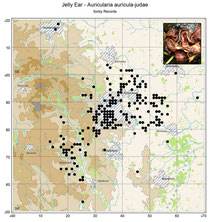
Jelly Ear Fungus records
Map of local records produced by Steve Clements and included in the Sorby Natural History Society Fungus Group Flikr stream. See link for details of the Sorby NHS.
Base Map courtesy of MuseumsSheffield and the Ordnance Survey. The image of Jelly Ear Fungus was added outside DatMapR!
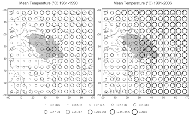
Mean Temperatures for the periods 1961-1990 and 1991-2006 for the Sorby NHS Recording Area around Sheffield (Yorkshire, UK). These maps use numeric data based in a 5km grid obtained from the Met Office, and were in fact produced using DatMap, the predecessor to DatMapR. The maps were drawn in 'Grid' mode. Two maps and a common key were then combined in Photoshop. The map is taken from the Sorby Record Special Series No 16 "Sheffield's Weather" written by Gaynor Boon and Adrian Middleton (the author of DatMapR) and available from the Sorby NHS web-site.
The base map was hand drawn (in Photoshop) from the OS 1:250,000 map (© Ordnance Survey) as a black on white line drawing which
could be used either as a background or as an overlay to the map. The symbols are 'un-filled round' of stepped increasing size and were generated as a 'Symbol Scheme'. The wide key was
generated by using the 'Extended Key Width' in the Map Formatting window - by
default the width of the key would be constrained by the width of the map area.
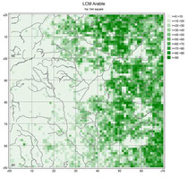
Area of Arable Land (as ha per km square, i.e. effectively percentage cover) derived from satellite images. The data was produced as part of the 'Land Cover Map 2000' and made available through the Countryside Information System (www.cis-web.org.uk).
The data is mapped in 'Grid' mode using square symbols of fixed size (1km), thus filling the area of the map. The symbol colours were generated as a 'Symbol Scheme' as shades from white to dark green. The base map, as in the previous example, was hand drawn as black on white (again from the OS 1:250,000 map (© Ordnance Survey)) and here used as an overlay since the mapped data covers the whole map area and would obscure a normal background.
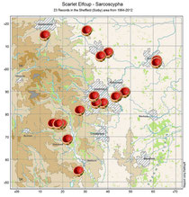
Locations for Scarlet Elf Cup around Sheffield, mapped using the new (v1.3) Icon facility. The Icon is based on a photograph of the fungus.
The map was produced by Steve Clements and included in the Sorby Natural History Society Fungus Group Flikr stream.

